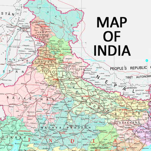
 Map of India


India map is also known as Bharat ka manchitra, India ka naksha. Map of India is a completely free a...
Read more
India map is also known as Bharat ka manchitra, India ka naksha. Map of India is a completely free a...
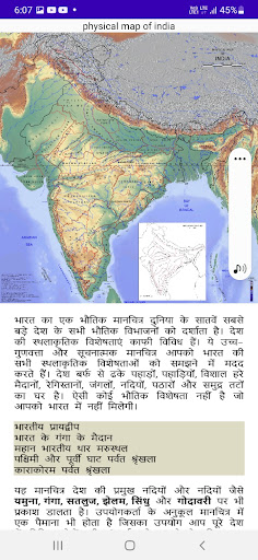
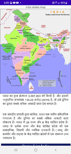
India map is also known as Bharat ka manchitra, India ka naksha. Map of India is a completely free app in all countries. This app is useful for every competitive exam student. The User Interface is developed very simply for better understanding and a good user experience. From this application, you can get maps and information charts.This App is sufficient Study Material for All Students who are keen to get command over Exams. India map app will also help you in various exams. It will be also useful for people searching for government jobs or for preparing for any entrance exams. like UPSC, CSAT, MPPSC, PSC, SSC CGL, SSC CHSL, IBPS PO, IBPS CLERK, POLICE, and numerous other government and PSU, Entrance exams.Features On Map of India APP:-Zooming in and zooming out FeaturesHigh-Resolution Maps of all the states and union territories.100% Offline workMap of India PDFIndia Political Map is a premium-quality HD map of the country showing the distribution of the 29 states and 7 Union territories.Each state is clearly demarcated on the map with precise state boundaries. The country boundary and location of the neighboring countries are also accurately shown on this colorful map.Additional information about the national capital city and the state capital cities is given here.This map can be used for presentations, educational purposes, etc.Map of India data taken from Wikimediahttps://commons.wikimedia.org/w/index.php?curid=57125449https://commons.wikimedia.org/w/index.php?curid=7381045https://upload.wikimedia.org/wikipedia/commons/8/83/Physical_Map_of_India.jpghttps://upload.wikimedia.org/wikipedia/commons/f/ff/Map_of_India.webphttps://commons.wikimedia.org/w/index.php?curid=110075268https://upload.wikimedia.org/wikipedia/commons/b/b1/India_map_en.svghttps://commons.wikimedia.org/w/index.php?curid=900243https://upload.wikimedia.org/wikipedia/commons/b/b6/Map-of-india-political-enlarge-view.gifhttps://commons.wikimedia.org/w/index.php?curid=44932706Include maps in the Application:-India Population MapIndia Climate MapIndia City MapIndia Airline MapIndia Road MapIndia MapIndia State and Official LanguageDistrict of IndiaIndia Literacy RateIndia world mapphysical map of Indiazone map OF IndiaIndia outline mapriver map of Indiarailway map of Indiageographical map of Indiablank map of IndiaIndia world mapold India mapPolitical Map of India with States India map with states and capitalsThe map shows the location of the following Indian State and Union Territories:Andhra Pradesh MAPArunachal Pradesh MAPAssam MAPBihar MAPChhattisgarh MAPGoa MAPGujarat MAPHaryana MAPHimachal Pradesh MAPJammu & Kashmir MAPJharkhand MAPKarnataka MAPKerala MAPMadhya Pradesh MAPMaharashtra MAPManipur MAPMeghalaya MAPMizoram MAPNagaland MAPOdisha MAPPunjab MAPRajasthan MAPSikkim MAPTamil Nadu MAPTelangana MAPTripura MAPUttarakhand MAPUttar Pradesh MAPWest Bengal MAPAndaman and Nicobar Islands MAPChandigarh MAPThe Government of NCT of Delhi MAPDadra and Nagar Haveli MAPDaman and Diu MAPLakshadweep MAPPuducherry MAPThank you for downloading the India map with all states